Sunday, January 8, 2012

Titan II Missle Silo 12/26/2011

The concrete doors on top of the silo

My final day in Arizona I visited the last remaining Titan II Missile Silo in the United States. Developed in 1963, today the area is a historical museum chronicling the Cold War between the United States and the Soviet Union. The Titan Museum is located twenty minutes south of Tucson, Arizona, in Sahuarita, Arizona. Tours start at 9 am and end at 4 pm. They cost $9.50 and are one hour long. Each tour is led by a docent who is very knowledgeable on the development of the Titan II Missle and the Cold War. Special tours including "Beyond the Blast Doors" are avaliable infrequently. Inquire at the museum. I recommend visiting the museum to understand our nation's history.

History: The Titan II missle or Intercontinental Ballistic Missle (ICBM) was developed in 1963 by the Air Force to supplant the Titan I missle. The Titan II was the first liquid propellent missle. It was always at the ready and could reach a target anywhere in the world within 30 minutes. It was propelled by two rocket engines with a nuclear warhead at the tip. Starting in 1963 three sites in the United States had Titans: Wichita, Kansas, Damascus, Arkansas, and Tucson, Arizona. Each location had 18 silos.

The missles were ment to check the spread of communism from the Soviet Union and also to deter the Soviet Union from launching their SS-9 (ICBMs) at the United States and starting a nuclear war. The concept became known as MAD or Mutual Assured Destruction. If the Soviets ever fired ICBMs at us we had the ability to fire our Titans and destroy their country. This deterrence worked and a nuclear war between the two countries never occured. The Titans were decommissioned in 1987 after two accidents at silos in Kansas and Arkansas and a nuclear arms reduction treaty with the Soviets. As a result of the treaty, all silo sites except for this one in Sahurita, Arizona, were destroyed. (Information from www.titanmisslemuseum.com, www.techbastard.com, and www.wikipedia.com)


Picture showing the mechanism to open the silo doors. Under the SALT treaty with the Soviets the doors were left open halfway.


Rocket engines which propelled the missle
In the event of nuclear war the silo had three antennas one of which popped up from underground


Backup communication antennas
Security blast doors


Suits used when workers were near the fuel of the missle which was poisonous


The corridor between the command center and silo itself


Control center. Panel in front shows simulated launch


Butterfly Valve Lock. Ment to insure against accidental launch


Another pic inside control room


Bisbee, Arizona 12/24/2011

One of the many staircases in Bisbee

On Christmas Eve I visited Bisbee, Arizona, with Tara's family to visit the historic copper producer in southern Arizona. From 1875 to 1975 the Copper Queen Mining Company (under the direction of Phelps Dodge and the Calumet and Arizona) mined copper, zinc, manganese, silver and lead. Presently, the town has kept its charm while attracting artists from around the world. Walking around Bisbee is one of my favorite activities. There are many historic buildings, staircases and alleyways to explore. Make sure to check out the Copper Queen Hotel and the local museum which gives a great history of the copper boom. I prefer Bisbee to the ultra-touristy Tombstone to the north.

Directions: Bisbee is located 94 miles south of Tucson on State Route 80 north of Douglas, Arizona, on the Mexican border.

Brief History: The boom began in 1875 when a US Army scout John Dunn staked a claim in promising rock he thought contained copper. Dunn put Warren in charge of the claim . Warren advertised the find and miners came in from around the United States. At first minimal smelting was done in the district and it was profitable to send the ore to Pennsylvania. In 1881 the Copper Queen Mining Company was struggling to make a profit. Douglas, on behalf of the Phelps Dodge Corporation, brought the Copper Queen Mine. Phelps Dodge responded by building a state of the art smelter in Douglas and a railroad line as well.

Phelps Dodge worked hard to turn around the lawless behavior of the men and the unsanitary conditions in the camp. Prior to 1881 it was common for men to work at the mines enubreated. A row of prostitute houses lined Brewery Gulch which facilitated the problem. The new company forced the houses to the periphery of Bisbee and instituted harsh policies on the miners working under the influence. In the early 1900s the Warren District was also known for instituting safety measures which led to less injuries. Finally, sanitary improvements limited Typhoid and Dysentery outbreaks.

Bisbee had its share of disastrous fires and floods. In 1906 and 1907 major fires destroyed residences and businesses along Main Street and Brewery Gulch. The 1907 fire was the biggest fire actually causing the mines to close while the miners could dynamite a firebreak. After the 1907 fire Bisbee created a fire department and state of the art fire truck. Because of the lack of tree coverage in the hills around Bisbee, every year floods still ravaged Bisbee causing major damage.

In the 1900s the Warren District would be known for the number of nationalities which worked its mines and strict segregation. England, Sweden, Germany, Mexico, Slovenia, Serbia, Italy all had workers in the area however, they were segregated by their job. Drillers and engineers were mostly dominated by Cornish and northern Europeans. Muckers were dominated by Central Europeans. Hispanics were not allowed in the mines and worked above ground in the smelters. Chinese were not allowed to stay in town after daylight hours. They could stay during the day to sell produce but were arrested if seen after dark.

1917 was an important year for the Warren District. First, Phelps Dodge brought out the Calumet and Arizona Mining Company becoming the dominant power. Second, the Sacremento Pit opened becoming Bisbee's first open-pit copper mine. Third, the deportation of strikers led by the Industrial Workers of the World (IWW) put a permanent stain on Bisbee's history. They were rounded up by law officers and sympathizers. The strikers were loaded into cattle cars and shuttled into the New Mexico desert.

The Lavender Pit, opened in 1951 became the prominent mine in the final 24 years of the Warren District. It was so large it actually required the removal of a number of homes and roads in the area. The pit would soon play out and close in 1975 ending mining around Bisbee. While in operation the mines in the Warren District produced: 8 billion pounds of copper, 355 million pounds of zinc, 324 million pounds of lead, 100 million ounces of silver, and eleven million pounds of manganese. Today there is talk of restarting mining production in the area. The cycle continues... (Information from: Bisbee Queen of the Copper Camps By: Lynn Bailey and Arizona Ghost Towns and Mining Camps by Philip Varney)
Street in Bisbee


Central part of Bisbee with the Mule Mountains surrounding town


The Copper Queen hotel in the center of town


Gleeson, Courtland, Pearce 12/23/2011

The cemetery in Pearce


Information: In the morning of December 23, Tara and I took a Jeep tour of three ghost towns to the east of Tombstone, Arizona. Our trip took us by the historic boomtowns of Gleeson, Courtland and Pearce. We drove out on the stage coach route from Tombstone to New Mexico. From Pearce we drove back on the historic Military Road that ran from Fort Bowie to Fort Huachuca. The highlight of the trip was definitely our tour guide Mark. He was a wealth of knowledge about the places we visited. For information on the jeep tours please contact Tombstone Jeep Tours.


History: For this blog I will give a short history of each ghost town we visited. For more information consult your local library and the internet.


Gleeson: The boom began in the late 1890 with the discovery of copper lead and silver by Jimmie Pearce. The first boom lasted until 1894 when the town was abandoned. In 1900 John Gleeson opened the Copper Belle and five other mines near town. He also moved the townsite into the flats. Production at the mines continued until 1919 when metals prices fell. As a result, people left town.


Courtland: In 1909 people flocked to the town to mine gold. At the beginning four different mining companies operated in the area. At its heighth the settlement had 2000 people a post office, newspaper, movie theater, pool hall and Wells Fargo office. The mines operated into the Great Depression but folded soon after. Today the town is a true ghost with only a few remains.


Pearce: The town was named for Jimmie Pearce who found free gold in 1894 outside of town. His claim would become the Commenwealth Mine. A post office opened in 1896 and soon the settlement had a population of 1500. Like other boomtowns in Cochise County the mines closed when they flooded. Today, Pearce has a general store twhich sells jams made from local plants such as prickly pear cactus and mesquite. (Information from: Arizona Ghost Towns and Mining Camps by: Philip Varney)


A Confederate soldier buried in Pearce's cemetery


Historic building in Pearce along the Ghost Town Trail


Ruins in the true ghost town of Courtland


Remains of the school in Gleeson


Anothe rpic of the school remains in Gleeson


Me in the jail of Gleeson with Mark our tour guide pointing a pistol at me


Tara on what was mainstreet Gleeson


The old jail in Gleeson. Prisoners would be chained to the tree


Mines on the hill


The saloon in town


Tombstone Boothill Cemetery 12/23/2011


Directions: The historic mining community of Tombstone, Arizona, is located about 69 miles southeast of Tucson by taking Interstate 10 and State Route 80. With over 200,000 visitors annually this is one of the most visited sites in Arizona. The popularity stems from its reputation as a rough frontier town with shootouts between Wyatt Earp and the Clayton brothers. Today, visitors can pay to see a reenactment of the shootout at the OK Corral, the historic Bird Cage Theater, Crystal Palace and the Courthouse. The Tombstone Courthouse is now a State Park and is worth a visit. However, there is a certain amount of fakeness to the town. The famous Boothill Cemetery was moved to accomodate tourists and many of the buildings are not in their orginal locations. In light of its touristy nature Tombstone is worth an afternoon.

History: The boom began in 1878 when ed Shieffelin found silver ore to the west of town. He named the claims Tombstone and Graveyard because of the rough reputation the area had gotten with settlers. While in Signal, Arizona, getting the ore assayed Sheiffelin became partners with the assayer Richard Gird. The mines boomed and between 1880-1886 the mines produced $40 million worth of silver. The ore could not be milled in Tombstone because of a lack of water so Gird created Millville nine miles west on the San Pedro River. The town of Fairbank, also to the west, became the central location for materials to be shipped in by rail. The town and area became known as a rough area because of numerous murders by outlaws and Apache Indians. Bandits also robbed the supply routes into town.

Heartache began in 1881 and didn't stop until the mines shut down forever in 1929. In 1881 and 1882 major fires burned a significant number of the bussinesses in town. Despite the fires, the town rebuilt and continued to be productive. In 1886 the shfts penetrated the underground water table; flooding the tunnels. As a result, the mines had to close and many residents moved to other boomtowns such as Bisbee to the south. Attempts to reopen the mines continued until 1929. Today there is very little active mining in the hills near Tombstone. (Information from Arizona Ghost Towns and Mining Camps by Philip Varney). For more information on Tombstone please consult the author Ben Traywick. The photos on this post are of the infamous Boothill Cemetery where many of those who died a violent death are buried.


Neat photo of the Dragoon Mountains across the valley


Wednesday, January 4, 2012

Fort Huachuca and the Buffalo Soldiers 12/21/2011

Soldiers at Fort Huachuca


The second day in Sierra Vista, Arizona, I visited the historical museums on Fort Huachuca with Tara and her mother. Fort Huchuca is located about an hour south of Tucson, Arizona, in Cochise County. Tara's dad recently obtained a job on the base with regards to military intelligence.


Histroy: In Fubruary of 1877,Colonel August Kautz ordered a camp to be established to protect settlers and travel routes in southern Arizona. It was also established to block Apache Indian escape routes into Arizona. The Apaches were a violent Indian tribe who killed soldiers and settlers throuhout the southwest. In 1886 General Miles used the fort as its headquarters and supply base in support for the campaign against the renegade Apacher leader Geronimo and his followers. Later in the year Geronimo surrendered in southern Arizona with the Mexican army blocking his escape route to the south and the U.S. Army to the north. The U.S. Army duped Geronimo into surrendering by claiming he and his followers would have freedom if they gave themselves up. However, the US incarcerated them for decades as prisoners of war. Fort Huachuca stayed open after the Apache wars because of persistent banditry and American outlaws.


The 10th Calvary "Buffalo Soldiers" arrived at Fort Huachuca in 1913 and stayed for 20 years. The 10th Calvary was composed of all African troops. Up until the 1950s African Americans could not serve with whites. As a result, they had their own regiments. These black soldiers became known as "Buffalo Soldiers," a name given to them by indians. The 10th Calvary joined Pershing in a 1916 expedition into Mexico to find and capture Pancho Villa- a mexican outlaw wanted for burning a New Mexico town. During World War II the 25th Infantry Division who were stationed in Arizona fought alongside the French in the European Theatre. Many of these soldiers fought with valor but were not recognized for decades.


After the Korean War Fort Huachuca became a part of the Army Strategic Communications Command. Under this command the Fort became instrumental in the testing of electronic and communications equipment. This would include the testing of drone technology. During the Cold war the base became the home of the U.S. Army Intelligence Center and School. As a result, many of the activities on base are classified. (Information from www.huahuca.army.mil/site/vistor/index


"Buffalo Soldier"


Plaque on base honoring the 10th and 25th Regiments


Statue honoring the "Buffalo Soldiers"


A tribute to the Indian scout


Coronado Memorial Park 12/22/2011

View south into Mexico


Wanting to give my wife some space with her family, I drove south of Sierra Vista to Coronado Memorial Park close to the border. The park is administered by the National Park Service to preserve the ecology of the southern Arizona desert. The park memorializes the Vasquez de Coronado Expedition up the San Pedro river and into Arizona. He was searching for the seven cities of gold and also exploring new land for the Spanish to colonize. (Information from nps.org)


Information: The park has no fee to enter and offers visitors many recreational options including hiking, birding, picknicking and sightseeing. It is important to remember that this is desert country so it is hot during the summer and cold during the winter. Carry plenty of water. Also the area is a smuggling route for drugs and illegals into the US so stay vigilant. While in the park I saw a large number of Border Patrol personnel and vehicles; however, at no point did I not feel safe. Inquire about trail conditions before venturing out.


Hiking: The park offers an abundance of hiking which is exactly what I came to do. I left the Visitors Center and drove to the top where the trail for Coronado Peak and the Crest Trail started. I hiked to the Coronado Peak (0.4 one way) and out Joe Canyon another 1.5. Hikers can see evidence of the July fire with burned signs and burned vegetation. It is always amazing to me how fast vegetation comes back after a wildfire. I hiked back to the trailhead and up the Crest Trail appr. 2.5 miles one way. This trail gained considerable elevation and was more difficult. Near the crest of the Huachucas I saw a number of abandoned mines with iron gates blocking them off. This park is one of my favorite in Arizona and offers widespread views of the Huachucas, Dragoons and into Mexico.

Desert vegetation in park; near crest of Huachucas


Pic of park from Crest Trail


Looking east from Coronado peak


Looking across the valley near Coronado Peak


Looking SW along the Huachuca Mountains


Ridgeline into Mexico
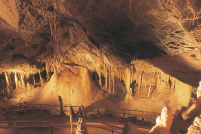


Kartchner Caverns State Park December 20, 2011

Soda Straws inside the cave


Over the Holiday break my wife and I traveled from Nevada to Arizona to visit family in Sierra Vista. While in Arizona we visited a number of interesting historical and ecological sites. This first post will chronicle Tara and my trip to Kartchner Caverns Statepark.


Information: Kartchner Caverns is located south of Benson, Arizona, about 20 miles. The cave was discovered in 1973 on land belonging to Mr. Kartchner. The initial discovery remained a secret for 14 years before Kartchner sold the land to Arizona State Parks. In 1993 work began on creating a suitable entrance to take visitors into the cave. Contractors did a great job in not destroying any features of the cave during construction. This is a live cave so formations are constantly forming.


Today, Arizona State Parks offers two tours- The Big Room and The Throne Room. Each tour is 1.5 hours long and costs $22.79. (The Throne Room tour is not offered from March to October because of roosting bats). During the Big Room Tour we saw many beautiful features including stalagtites, stalagmites, soda straws, turnups, bacon and eggs. Our guide was very informative giving us ample information on the cave's development and features inside the cave. It is important to remember that volunteers lead many of the tours. and are instrumental in maintaining many of our state parks and historic sites. (Information and pictures inside the cave from Arizona State parks)


Hiking: Above ground a 2.5 mile loop trail gives visitors great views of desert life and the surrounding mountains. An access trail also leads into the National Forest.

Camping is offered in the State Park at $14 per night.


Inside the Big Room


Ocotillo in the foreground, looking across valley


Kartchner Cavens State Park; notice the many different species of plants including agaves, ocotillo, yucca.


Kartchner Caverns State Park