The original telephone poll on the border
For a small town West Wendover and Wendover, Utah, have a significant amount of history. On this blog I have posts on the Wendover Airbase, California Trail and Pony Express. (The Pony Express didn't come through town but 50 miles to south). This post is dedicated to an overlooked memorial near the Montego Casino commemorating the completion of the first Transcontinental Telephone Line in 1914.
Plaque giving history on the event
Saturday, March 23, 2013
Tuesday, March 19, 2013
Leppy Peak Hike Eastern Nevada March 16, 2013
Location and hike: The Leppy Hills are located to the north of West Wendover. This range is overlooked because it has sparse vegetation and travelers want to hike other more picturesque ranges. However, on my various hikes I have seen great views, caves, interesting rock formations and Bighorn Sheep. A hiker has to be willing to hike off-trail or on ATV trails not on traditional hiking trails. Today I am hiking on the highest peak: Leppy Peak at almost 3,000 feet. It is impossible for me to describe the route because it is entirely off-trail. Be careful when hiking off-trail and remember to use common sense. Today I was rewarded with watching eleven Desert Bighorn Sheep for over an hour. Enjoy some of my favorite pictures from the hike. It was amazing how nimble the sheep were on extremely rocky and steep terrain.
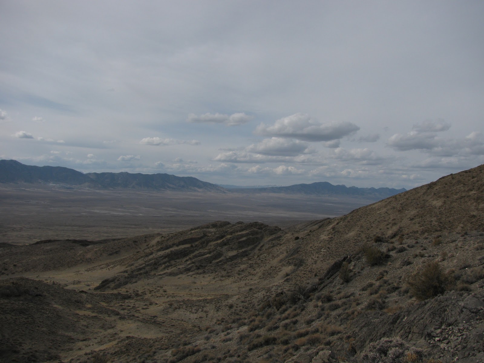
Looking south from on the ridge of Leppy Peak
Looking north toward Silverzone Pass
Friday, March 8, 2013
Silverzone Pass on the Union Pacific Eastern Nevada March 2013
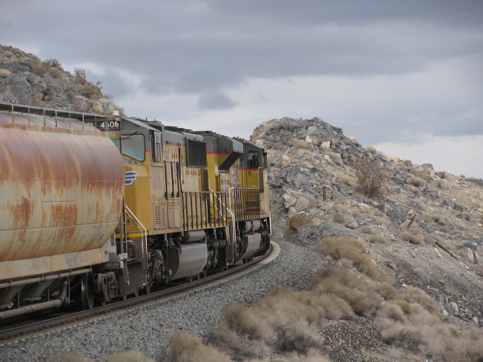
A westbound Union Pacific grain train enters a rock cut on Silverzone Pass
On two seperate trips I explored various parts of Arnold's Loop on the Union Pacific to photograph trains climbing over the Toano Mountains in Eastern Nevada. The railroad gains elevation quickly by looping over itself. At my favorite spot an observor can see trains on two different levels. Most of the photos on this post come from my second trip when I chased three westbounds from West Wendover on Interstate 80. I love this area because you see trains, great scenery and wildlife. Remember to stay away from trains and carry provisions such as water. On this blog I have included my favorite pictures of the trains as well as a herd of deer.
Herd of mule deer
UP grain train near siding at lower part of pass
Westbound climbing grade; if you look closely you can see the tracks on the upper side of the hill to the right.
Same westbound at end of siding on lower part of loop
Chugging toward the rock outcrop
Lower tracks with train on upper part of hill after it has gone around loop
On two seperate trips I explored various parts of Arnold's Loop on the Union Pacific to photograph trains climbing over the Toano Mountains in Eastern Nevada. The railroad gains elevation quickly by looping over itself. At my favorite spot an observor can see trains on two different levels. Most of the photos on this post come from my second trip when I chased three westbounds from West Wendover on Interstate 80. I love this area because you see trains, great scenery and wildlife. Remember to stay away from trains and carry provisions such as water. On this blog I have included my favorite pictures of the trains as well as a herd of deer.
Herd of mule deer
Another pic of deer
Train on upper part of pass. It has already gone around the loop.UP grain train near siding at lower part of pass
Westbound climbing grade; if you look closely you can see the tracks on the upper side of the hill to the right.
Same westbound at end of siding on lower part of loop
Chugging toward the rock outcrop
Lower tracks with train on upper part of hill after it has gone around loop
Sunday, February 24, 2013
Northern part of Toano Mountains of Nevada Exploration February 17, 2013
Looking west toward the Pequop Mountains
Location: The area I am exploring is the northern part of the Toano Mountains north of the Shafter exit on Interstate 80 in eastern Nevada.
Nevada and I spent about three hours hiking along a ATV track because it was easier walking. In the pinyon pine and sagebrush there was 10 plus inches of snow on the ground making harder walking. During our hike we met two coyote hunters out for the day who were talkative. Later on this spring I am going to climb the mountain in photograph number three. It appeared there was a relatively easy way to the top. Enjoy my photographs and remember Nevada is a beautiful state.
Nevada in the snow
The mountain I want to climb later in the spring. You can see the band of green to the top
Nevada in eastern Nevada
Looking west toward the Pequop Mountains and Shafter Valley.
Location: The area I am exploring is the northern part of the Toano Mountains north of the Shafter exit on Interstate 80 in eastern Nevada.
Nevada and I spent about three hours hiking along a ATV track because it was easier walking. In the pinyon pine and sagebrush there was 10 plus inches of snow on the ground making harder walking. During our hike we met two coyote hunters out for the day who were talkative. Later on this spring I am going to climb the mountain in photograph number three. It appeared there was a relatively easy way to the top. Enjoy my photographs and remember Nevada is a beautiful state.
Nevada in the snow
The mountain I want to climb later in the spring. You can see the band of green to the top
Nevada in eastern Nevada
Looking west toward the Pequop Mountains and Shafter Valley.
Friday, February 22, 2013
Atomic Testing Museum Las Vegas, Nevada February 9. 2013
Timeline highlighting important events in the 50s
Location: The Atomic Testing Museum is located on East Flamingo Road at the Desert Research Institute (DRI). To get to the DRI turn off of Las Vegas Blvd near Tropicana Casino.
General Information: Admission is $14 for the museum and $6 more for the special Area 51 Exhibit. Military and Nevada residents get in for $11.This museum has alot of great information. To see everything I would allocate at least 2-3 hours at the location.
Exhibits chronicle the develoment and testing of the Atomic bomb in the United States and throughout the world. In the first part of the museum displays give information about the Cold War and the need to respond to the nuclear threat presented by the USSR. It continues with the development and detonation of the Atomic bomb in New Mexico code named Trinity. After the Trinity Test, the United States Government tested bombs in the Pacific at Bikini Atoll. The rest of the museum gives information on the development of the Nevada Test Site and the approximately 900 above and below ground tests conducted primarily at Yucca Flat and Frenchman Flat. The Area 51 special exhibit has some good information but I do not think it is worth the $6 admission. Museum curators spent way too much information on the UFO conspiracy in New Mexico as well as Groom Lake. (Some information from the Atomic Testing Website). In a later post I will give a comprehensive history of the Nevada Test Site.
Craters from underground test at Yucca Flat
Diagram showing an underground test in a mine at the Nevada Test Site
America's largest underground test was not in Nevada but in Alaska
Map showing nuclear detonations at the Nevada Test Site
Information on the different levels of nuclear waste; Yucca Flat has become a respository for low level waste
Badge used at the Nevada Test Site
Geiger instruments used to monitor radiation
An istrument used to take pictures and record scientfic information during an underground detonation
Organized Crime and Mob Museum Las Vegas, Nevada February 9, 2013
Information panel talking about the end of Prohibition
Location: The Organized Crime and Mob Museum is located at 300 Stewart Avenue in downtown Las Vegas at the old Court House. If driving from The Strip; take Las Vegas Blvd until you reach Stewart Avenue. This can be a long drive in traffic so stay patient. Turn left onto Stewart Avenue and the museum will be on the right. Parking is available next door for a fee however, free parking is available at the Farmer's Market lot.
General Information: Admission is $19.95 for the General Public, $15.95 for Seniors and Military and $10 for Nevada residents. This museum is very informative and I highly recommend allocating a significant amount of time to visiting it. Exhibits tell the story of the mob from its inception around Prohibition to present day. Visitors learn about such mobsters as Lucky Luciano, Al Capone, Bugsy Siegel, Whitey Bulger and many more. Exhibits also tell how law enforcement evolved their techniques to catch and prosecute mobsters through the use of undercover officers and informants. Finally, a large section is devoted to organized crime in Las Vegas, Nevada. (Some information from the Mob Museum website).
John Roselli information plaque
Alcohol Testing Kit and Evidence bottles from Prohibition era America
Prohibition era liquor bottles
A thematic map of early Las Vegas
Actual wall from the Valentine's Day Massacre which indirectly led to Capone's downfall
A "Tommy Gun." Popular weapon used by hitmen.
Performers at the Cotton Club
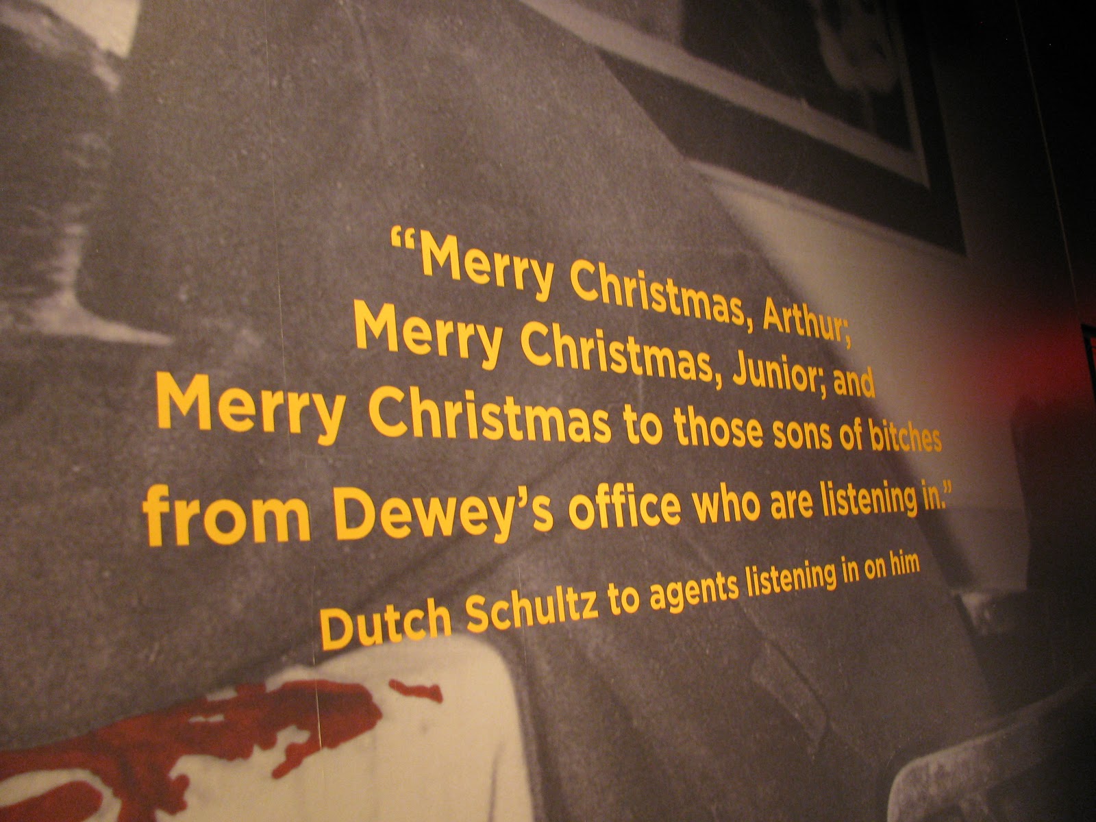
Interesting quote
Exhibit on early Vegas
Handgun used by police forces
Location: The Organized Crime and Mob Museum is located at 300 Stewart Avenue in downtown Las Vegas at the old Court House. If driving from The Strip; take Las Vegas Blvd until you reach Stewart Avenue. This can be a long drive in traffic so stay patient. Turn left onto Stewart Avenue and the museum will be on the right. Parking is available next door for a fee however, free parking is available at the Farmer's Market lot.
General Information: Admission is $19.95 for the General Public, $15.95 for Seniors and Military and $10 for Nevada residents. This museum is very informative and I highly recommend allocating a significant amount of time to visiting it. Exhibits tell the story of the mob from its inception around Prohibition to present day. Visitors learn about such mobsters as Lucky Luciano, Al Capone, Bugsy Siegel, Whitey Bulger and many more. Exhibits also tell how law enforcement evolved their techniques to catch and prosecute mobsters through the use of undercover officers and informants. Finally, a large section is devoted to organized crime in Las Vegas, Nevada. (Some information from the Mob Museum website).
John Roselli information plaque
Alcohol Testing Kit and Evidence bottles from Prohibition era America
Prohibition era liquor bottles
A thematic map of early Las Vegas
Actual wall from the Valentine's Day Massacre which indirectly led to Capone's downfall
A "Tommy Gun." Popular weapon used by hitmen.
Performers at the Cotton Club
Interesting quote
Exhibit on early Vegas
Handgun used by police forces
Quintin and I at the museum
Tuesday, January 29, 2013
Randsburg, CA January 3, 2013
Downtown Randsburg
Location: Randsburg is located between Ridgecreat and Kramer junction off of US 395. It is also 69 miles north of Victorville, California. I would suggest not visiting during the summer because daytime temperatures are well in the 100s. During the rest of the year this area is popular with off-road vehicle enthusiasts.
History: The boom began in 1895 when three prospectors discovered gold at the Rand Mine. Despite the heat and lack of water in the area some prospectors came. However, over a year later in May of 1896 Rand Camp was still small with only three saloons and a boarding house. This would all change in the fall of 1896 when the cooler weather prompted people to arrive in droves. Stage coaches arrived three times a week with prospectors and their families hoping to strike it rich. Within a year builders had built houses, restaurants, a school, churches and post office.
The early camp was known for its general lawlessness. With so little water in the area and so many bars in town the alcohol flowed freely. This led to many skirmishes which resulted in fights, stabbings and murder. There were four murders in the fall of 1896. Later a group calling themelves the "Dirty Dozen" would become implicated with these murders as well as others that occured in Randsburg. Stories permeated western newspapers about the violence; ultimately slowing the development of the town. (Information from www.ghosttowns.com, www.randdesertmuseum.com and www.wikipedia).
Stamp used at one of the mills used to process the ore
Saloons were prevalent in Randsburg
Old truck in town
Antique shop in town
City Jail
Location: Randsburg is located between Ridgecreat and Kramer junction off of US 395. It is also 69 miles north of Victorville, California. I would suggest not visiting during the summer because daytime temperatures are well in the 100s. During the rest of the year this area is popular with off-road vehicle enthusiasts.
History: The boom began in 1895 when three prospectors discovered gold at the Rand Mine. Despite the heat and lack of water in the area some prospectors came. However, over a year later in May of 1896 Rand Camp was still small with only three saloons and a boarding house. This would all change in the fall of 1896 when the cooler weather prompted people to arrive in droves. Stage coaches arrived three times a week with prospectors and their families hoping to strike it rich. Within a year builders had built houses, restaurants, a school, churches and post office.
The early camp was known for its general lawlessness. With so little water in the area and so many bars in town the alcohol flowed freely. This led to many skirmishes which resulted in fights, stabbings and murder. There were four murders in the fall of 1896. Later a group calling themelves the "Dirty Dozen" would become implicated with these murders as well as others that occured in Randsburg. Stories permeated western newspapers about the violence; ultimately slowing the development of the town. (Information from www.ghosttowns.com, www.randdesertmuseum.com and www.wikipedia).
Stamp used at one of the mills used to process the ore
Saloons were prevalent in Randsburg
Old truck in town
Antique shop in town
City Jail
Subscribe to:
Posts (Atom)