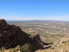
Directions and Information: The Linda Vista Trail head is located off of the Oracle Road. From I-10 take the Ina Road exit (Exit 248). Head toward the Catalina Mountains. When you get to Oracle Road turn left traveling north. Turn right onto Linda Vista BLVD. The small trail head for Linda Vista is on the right. The parking lot accommodates about six cars and fills up quickly on weekends so arrive early.The main trail at Linda Vista is a 3.8 mile loop that gains about 500 feet. It gives visitors a great view of the Tortolita Mountains as well as Oracle Valley. This trail is popular with novice hikers and trail runners. An unimproved trail also takes visitors to the summit of Pusch Peak.
Today I am climbing Pusch Peak from Linda Vista. Pusch Peak is a prominent peak on Pusch Ridge in the western part of the Catalina Mountains. It does not have a Forest Service maintained trail to the top. Hikers have created an unimproved, steep and rocky trail to the top. As a result of it being unmaintained, this trail is frequented by few hikers so please be careful and hike with someone else.. The trail is short at 4 miles but gains about 2700 feet making it extremely steep. The first part of the hike is on the Linda Vista loop. This is the easy part of the hike with moderate elevation gain. After about 0.5 mile to one mile the Pusch Peak trail departs on the right at a sign warning visitors that the trail is unmaintained. At this point the trail immediately becomes steep, gaining elevation quickly. In the first mile I became apprehensive about hiking this trail by myself so I befriended a University of Arizona student who agreed to hike with me. Make sure to pay attention because it is easy to loose the trail in places. Also hike in a controlled manner because there are many plants that would hurt if you fell into them. Near the top of the peak we met a ten year old hiking with his father. I found this very impressive because most ten year old kids usually do not hike steep trails. The view from the top was extraordinary with Mt. Lemmon to the north, Santa Rita Mountains to the east, Tortolita Mountains to the West, and Tucson in the valley below. Please take your time descending because it is extremely rocky and steep making it easy to fall and injure a knee. (Information from www.localhikes.com/Hikes/LindaVistaLoop and www.hikearizona.com).


