Tuesday, August 19, 2014

Miller Canyon, Huachuca Mountains August 16, 2014

                                    Sonoran kingsnake

Hike Location: Drive south from Sierra Vista, Arizona, on State Rout 92 for nine miles. Turn right onto Miller Canyon road and drive until the trailhead, This road is an improved dirt road and it will accommodate passenger vehicles.

Miller Canyon is a nice alternative to the more popular Ramsey Canyon. It is about four miles and an elevation gain of 2700 feet to the Huachuca Crest Trail. This route also offers an alternative to the summit of Miller Peak. This canyon like the others in the Huachuca Mountains traps cooler air making it a nice microclimate for Syacamores and Douglas firs along with many species of pine. Most visitors do not realize that the mountains get cooler and wetter as you go south in this part of Arizona.

After leaving the trailhead the trail skirts around a private ranch at the base of the canyon. Past the ranch the trail returns to the canyon floor where it joins an old dirt road. Here the forest is delightful with shade from large oaks, After a half mile a trail to Hunter Canyon exits on to the left. In this part of Miller Canyon the trail can be hard to find because of floods in the canyon therefore, look for yellow flagging on trees which will mark the route. After about two mile the trail leaves the bottom of the canyon and climbs the right wall of the canyon. In this section of trail I came real close to almost getting bit by a Mojave rattlesnake. Luckily, I was hiking in front of two people who could have helped me if I had gotten bit. This part of Miller Canyon is heavily forested and high in elevation not the usual habitat for a Mojave.  I would have bushwhacked around the snake if there hadn't been Poison ivy along the trail. After ten minutes it became apparent that the snake would not move and I made the decision to turn around. I decided to hike the Hunter Canyon Trail because it was still early in the day. This trail ascended the southern wall of Miller Canyon before descending into Hunter Canyon. This canyon trail turned out to be a surprise because it gave me great views of Miller Canyon along with Miller Peak. As I returned to the trailhead a storm blew in over Miller Peak. At this time of year these storms are capable of producing lots of lightning, hail and rain which can be fatal if hikers are not prepared. Total mileage for the day was about seven miles with 1700 feet of elevation gain. (Information from Hiking Arizona's Cactus Country by Erik Molvar)

                                        Sunflowers

                          Mojave rattlesnake

                           A beautiful but deadly snake.

    Hunter Canyon

                 North wall of Miller Canyon

                       A beautiful lizard right off of the Hunter Canyon Trail.

                               Great picture of him on a rock.

Oracle Ridge Catalina Mountains August 9, 2014

                          Corral bells

Location: Take the Catalina Highway about 23.5 miles and turn right onto Oracle Control Road. Follow this road downhill passed the Mount Lemmon Fire Station. The trailhead is another 100 years along the road. If you have a jeep or all-terrain vehicle it is possible to drive down to Oracle, Arizona, by an unimproved dirt road.

The Hike: The trail along Oracle Ridge is actually the Arizona Trail which starts along the Mexican border and ends at the Utah border. This section is about 13 miles one-way and it ends at the American Flag Trailhead near Oracle, Arizona. It follows the ridge that extends northward from the Santa Catalina Mountains. Along the way are splendid views of the San Pedro Valley and Catalina Mountains. Many people hike the ridge to see its wildflowers which can be abundant in August.

Immediately after leaving the control road the trail climbs to over 8000 feet through a burned forest. Here I saw many species of wildflowers including Paintbrush, Corral bells and Sunflowers. The trail then descends to Stratton Saddle where it intermittently joins an old jeep trail for the descent to Dan Saddle. Make sure to keep an eye out for the wooden trail signs and the Arizona Trail blaze. At Dan Saddle a trail departs to the left descending to Catalina Camp and the Red Ridge Trail. The trail passed Dan Saddle is overgrown in places so watch your footing. The trail ascends precipitously climbing 500 feet in a half-mile. Keep an eye out for the Biosphere to the west. I would also watch for rattlesnakes because they like to sun themselves on the rocks. I hiked to the old Jeep trail near Rice Peak about four miles and turned around. Total mileage for the day was about eight miles with 1500 feet of elevation gain. (Information from Hiking Arizona's Cactus Country by Erik Molvar).

                 Along the ridge

    Looking west toward the reef.

      This truly is a beautiful trail.

                                 Sunflowers

     A burned forest with Red Ridge in the background.

        Vegetation along the ridge with a tall Century plant.

    Looking east across the San Pedro Valley.

                 I cannot go a summer without seeing Paintbrush.

   Corral bells

Sunday, August 3, 2014

Blacketts Ridge August 2, 2014

               Gila monster in the bush

Last Saturday I awoke to cloudy skies and cooler temperatures.  I also noticed a forecast of a 40 percent chance of rain. I threw my raingear in the backpack and drove up to Sabino Canyon. Sabino Canyon is not a summer hiking area because it is low elevation and can be hot. I arrived at the parking lot at 9:15 am. My objective is to hike Blacketts which is a about a six mile out and back with an elevation gain of 1700 feet.

Trail Description: The first 0.8 mile is in the main trail heading toward Bear Canyon. This trail is very popular and easy to follow. Various trail exit this one including Esperero Canyon and Sabino Canyon. After crossing Sabino Creek look for the junction with the Phoneline Trail on your left This trail is about five miles long and goes to the upper part of Sabino Canyon. Make sure to watch your footing because this trail is very rocky. A half mile later is the junction for Blacketts Ridge. Watch your footing on this trail because there are many loose rocks. After a mile it appears the trail ends at a nice shade tree. Watch for a fainter trail that continues to a sign at the top of the ridge. Views at this spot are spectacular; however, this is not a spot I would want to be in a lighting storm. Lucky for me it did not rain until later on in the day.

On the hike I saw  number of really interesting reptiles. Ten minutes from the parking lot I saw a Gila monster on the right side of the trail. I watched him for ten minutes before moving on. This Gila Monster was very active and even pawed at the ground a few times.  On the Blacketts Ridge Trail I saw a Desert tortoise. Desert tortoises are rare throughout the Sonoran and Mojave deserts and hikers can go years without seeing one.

                        The coolest reptile I have seen since I moved to Arizona.

                       Desert tortoise

                         Another picture of the tortoise climbing a rock

       A multi-colored lizard

    The view toward Tucson. The cloudy day made for softer lighting.

       Looking toward Bear Canyon near the top of the ridge.

      Sabino Canyon at the left. Mount Lemmon is also to the up.

        An Ocotillo with leaves.

              The upper part of Blacketts Ridge

              Blooming Hedgehog Cactus

Saturday, August 2, 2014

Mount Lemon Catalina Mountains Marshall Gulch and Aspen Trail July 3, 2014

                 Aspen Trail scenery

During the summer Mt. Lemmon is a great area to get away from the oppressive heat of the valley. It is possible to hike in 70 degree while temperatures in Tucson are over 100 degrees. Today I chose to hike out of Soldier Lake about three miles from the small community of Summerhaven, Arizona.

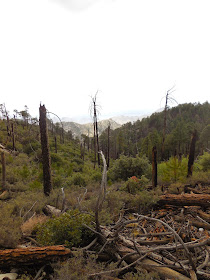
The Hike: I started out hiking the Sunset Trail which is approximately 1.6 miles long. It descends through a forest of conifers to the Marshall Gulch trail head. In the future I would probably skip this trail and start at Marshall Gulch. One plus of the Sunset Trail is that the forest did not burn during the  Aspen Fire of 2003 so most of the Ponderosa pines are more impressive. The next part of today's hike is on the Marshall Gulch Trail This trail is 1.2 miles long. The first 0.7 miles is in Marshall Gulch which is a nice water source for most of the year. While the view is not splendid in Marshall Gulch I did see three species of wildflowers including Mountain columbine. The last half mile the trail climbs to Marshall Saddle. At 7920 feet this saddle provides the first view of the upper part of Mount Lemmon and the Wilderness of Rock part of the Pusch Wilderness. I returned to Soldier Canyon by way of the Aspen Trail (2.5 miles). This trail was my favorite because of the views toward the valley. The forest in this part of Mount Lemmon is still recovering from the Aspen Fire of 2003. I saw many mature Ponderosa pines and Douglas firs with fire scars as well as many three to four foot conifers growing. This trail shows the power of fire and rejuvenation as well. The last part of the loop was on the Sunset Trail. Total mileage 6.9 miles.

            Young conifers growing

     Regrowth after a fire.


                   View toward Tucson.

                    This part of the trail was thinned.

Pima Air and Space Museum Nighttwings June 27 2014

                                     Quintin at Pima Air and Space

Summer in Tucson, Arizona, is miserable. A cool day in June is 98 degrees. To combat the cabin fever of staying inside for hours during the day many museums have extended hours and they offer kid friendly activities until 9:30 or 10 pm. Pima Air and Space offers Night Wings three times during the summer. On this particular night Radio Disney was offering entertainment in Hangar One. (Many other institutions including the Tucson Botanical Gardens and the Reid Park Zoo offer special night events during the evening. Inquire online.)

                Night Wings offers photographers softer light and better lighting conditions

                          Kennedy and Johnson's Air Force One

                       Bomber with setting sun

                             Bomber in the evening