Thursday, August 11, 2011

North Furlong Creek to Roads End 8/8/2011

Last light on Wines Peak

I would start on my Harrison Pass post and read this one last. These four posts are about a backpacking trip I took in the Ruby Mountains of Central Nevada.

I woke up my last morning in the wilderness well rested and ready for my last day on the trail. I ate a breakfast of oatmeal with dried fruit, purified some water and packed up my camp. Today would be a relatively easy day with approximately 7 miles to Roads End. I left camp at 7:50 am and easily summited the low divide between the North Furlong drainage and Favre lake drainage. An hour later I arrived at Favre lake and took a ten minute break before beginning my final climb to 10,400 foot Liberty pass. By mid-morning I summited relieved to be on top. I celebrated with a snow slushy and then descended to Lamoille lake. I ate some trail mix lakeside then hiked by Dollar lakes to my car at the Road's End parking lot arriving at 12:30. Overall, the trip was awesome with beautiful lakes, views, and stars. My feet performed very well with no blisters or sore spots. This is certainly one of the premier hikes in the west.

On top of Liberty Pass

Look down on Liberty lake

Scenery on the descent into the Favre lake drainage
Scenery in upper part of North Furlong drainage


Overland lake to North Furlong 8/7/2011

Looking toward the Ruby Dome with Lupine in foreground

I woke up at 5:15am after some stargazing and a good nights sleep. I quickly packed up my camp and by 6:40 am I was ready to start hiking. Today would be my longest day 13 miles with a long stretch of no water. The day before I agreed to hike with a backpacking group from the eastern United States. We started off descending 500 feet into the Overland Creek drainage. After crossing our last water source we ascended about 2,000 feet to the crest approximately 10,300 feet in elevation. The major part of the day was spent descending in and out of the uppper parts of the Long Canyon drainages. To exit the Long Canyon area the trail ascended to two small divides of 10,600 and 10,700 feet. From the beginning of the day the views were incredible and stayed unbelievable for the whole day. It is impossible to convey what it is like to hike on top of the world. Before descending into the North Furlong drainage we switchbacked up to a highpoint on the RCT of 10,900 feet on Wines Peak. I reached my destination at 3:30 pm and immediately ate a big lunch and lay down exhausted. I hiked in front of the Tennessee group all day and they arrived an hour later. That night I camped in the upper part of the drainage. For my final dinner in the wilderness I ate Lasagna with meat sause. I observed the stars for a while and then fell asleep.

On top of the world; looking north from Wines Peak


Looking south east from trail

Looking south from Wines Peak


The view hiking out of the Overland drainage

High country in the Ruby Mountains
Waterfall in the Overland drainage


Early morning sun at Overland Lake


McCutcheon Creek to Overland lake August 6, 2011

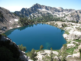
Overland Lake from above

After a good nights sleep I woke up at 6:30 am to clear blue sky. The weather was crisp and cool while I packed up my tent and sleeping bag. The first hour and half I climbed out of the McCutcheon and Dry Fork drainages to the top of South Fork. The trail up to this point was overgrown in spots but easy to follow. I saw many wildflower species including Paintbrush, Larkspur and Sunflowers. From looking at the map I could see that I had to hike into and out of the South Fork, Middle Fork and North Fork drainages. Seperating South Fork and Middle Fork was a ridge which the trail switchbacked up and over. In the South Fork drainage the wild flowers were beautiful and I saw a great place to camp in the future. I reached a low point on the RCT of 7400 feet in North Fork Canyon. From looking at my map, I could see that I had to gain 3,000 feet of elevation to climb out of the drainage. Parts of this climb would be the toughest of the four days. The sun was brutal and I felt I could not drink enough water. Also the switchbacks were long and seemed to go on forever. After four plus hours in the three drainages I finally crested North Fork pass. I rested for a few minutes and continued on. Ten minutes later the trail was covered by a steep snow field 100 yards wide. I slowly crossed it knowing that slipping was not an option. Above Overland Lake I reconnected with the RCT and descended to the lake. I arrived at 3:30 pm tired and hungry. At the lake I met a group of guys with horses. They were cooking hotdogs and gave me two for lunch. That night I ate chiken and rice for dinner. After dinner I hung out with a group of backpackers from Tennessee and Pennsylvania. It felt good to know another group was hiking north on the RCT.

Trail junction in South Fork Canyon

Above Overland Lake

Looking south on the pass above the North Fork drainage
Looking into North Fork Canyon


Wildflowers in the South Fork drainage


Above South Fork drainage


Looking toward McCutcheon in the early morning


Ruby Crest Trail Harrison Pass to McCutcheon Creek August 5, 2011

A poor picture of me on the Harrison Pass road

Over the course of four days and three nights I hiked the Ruby Crest Trail (from now on RCT) from Harrison Pass to Lamoille Canyon. The trail is approximately 38 miles long with a low elevation of 7,247 feet in the North Fork drainage to a high point of 10,900 feet on Wines Peak. Overland Lake to North Furlong Creek is the highest portion of the trail with hikers staying well over 10,000 feet for the day. Major tree species of the Ruby Mountains include Aspen in the drainages and Whitebark pine in the upper elevations. Major animal species include Mule deer and Bighorn sheep.

The hike: Today my objectives included hiking into McCutcheon Creek which is about 7 miles from the road. I left my wife at 9:00 am still feeling the effects of a stomach ache from the morning (I barely ate any breakfast). The first five miles of the hike involved walking on a dirt road and two track. Green Mountain is the trailhead for the RCT on Forest Service road 107A however, it is down a rough dirt road. The sun was already high in the sky making for a hot morning. After leaving the car, I felt better and hiked pretty fast. I do not like hiking on roads and wanted to get into the wilderness. Passed Green Mountain I met a nice individual on an ATV who confirmed my route and who voluntarily filled up my water bottle. McCutcheon Creek was only 2 miles from the wilderness boundary and I arrived after 1 pm. While eating lunch I debated about moving on but decided against it. I read until 4:00 pm at which time I pitched my tent in a grove of Aspen away from a group with the Great Basin Institute. For dinner that night I ate dehydrated Pasta Primavera.


Cool pic of tree at sunset; around 8 pm.


Looking west at sunset.


Trail signs at McCutcheon Creek

Southern Ruby Mountains scenery


Paintbrush off the trail

Looking south towards Harrison Pass